
NASA Scientific Visualization Studio
First the bad news: Extreme weather conditions are on the rise, not only in North America, but in Central Europe as well. They are not coincidental, as experts point out. The good news: By Wednesday it will finally clear up – maybe.
Summer in western North America and Scandinavia on the one hand, a cold and rainy summer in Switzerland on the other – unusual weather patterns seem to be more and more common. But what are the reasons for this?
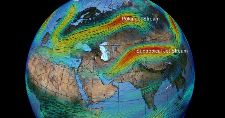
Meteoschweiz meteorologist Christoph Voisard, explains “Blue News”: “The deciding factor is the Rossby waves in the polar jet stream, a band of air at altitudes of 9,000 to 12,000 metres.” These waves are produced by the balance between cold polar air and warm subtropical air masses.
Jet streams are strong winds up to 500 km/h that circle the globe from east to west. The polar front jet stream that determines weather in the Northern Hemisphere is currently giving experts a headache. Usually the jet stream moves further north, at about 60 degrees north latitude.
jet stream is stuck
Researchers are recording more and more weather conditions in which the current becomes more wavy at higher altitudes: the jet stream shifts, stops, and may even become jammed. In 2018, for example, an unusually fast wavy jet stream got stuck in one place. The result: heat gathered under the waves in three regions – in Europe, Japan and the western United States.
“Even this year, the path of the high-altitude current has shifted south and has been stuck over Europe for several weeks,” Voisard says. There the jet stream waves “form a kind of trough, with polar air on one side and subtropical air on the other”.
Asked if it’s normal for the jet stream to be so far south, Voisard laughed briefly: “What’s normal?” It is true that there has been no damp and cool summer in recent years, “on the contrary: we were suffering from a high-pressure situation, so to speak”.
Still, “it is very difficult to specify predicates such as normal and abnormal. However, I would describe the fact that temperatures on the west coast of North America are exceptionally high, reaching around 50 degrees Celsius,” Voisard says.
moist and cold instead of hot and dry
Currently there is an air mass limit over Switzerland: “This means: on the one hand, moist air is carried from the south to the Alps. On the other hand, cold air from the north forms a kind of ramp,” explains the meteorologist. When these two air masses meet, it is always raining, often cloudy.”
“The deciding factor here is the current at altitude: If I look at today’s map, I see a high pressure condition from Ukraine to northern Russia – and this trough is over Switzerland, which brings a lot of precipitation. Atlantic There is again a high pressure condition extending from north to south of Greenland.”
One speaks of omega formation in this context: depending on where the different parts of the omega are located, it is either hot and dry or moist and cold. In the summer of 2018, Switzerland was south of the Omega Arc: the result was a heat wave. This year it is on the other side. The weather condition in Central Europe is not very hot, but it can appear frequently. “We experienced that in 2014, for example,” Voisard recalls.
Heat waves 150 times more likely to be caused by climate change
In the United States they say Omega Location instead heat dome, explains Dominic Schumacher from the Institute of Atmospheric and Climate Sciences at ETH Zurich. Scientists included in previously unpublished journal Study (PDF download) Involved in the World Weather Attribution (WWA) project: Researchers from several countries investigated extreme heat in the United States and Canada.
“It is not easy to analyze such events so quickly,” explains Schumacher in an interview with “Blue News”. “It is important to know that the simulations we used already exist. We analyzed the available data and assessed how likely such an event is in the current climate and in climates without human-induced warming. How likely is that.”
Based on the measurement data, the study used statistical methods to determine whether extreme heat in western North America occurs every 1000 years – that is, very rarely. But scientists also conclude that global warming due to greenhouse gases has made a heat wave 150 times more likely.
If the global climate continues to warm – 2 °C instead of the current 1.2 °C – such an event could happen every five to ten years. It could also be that something is currently changing in the region and there will be even higher temperatures in the future, say the ETH scientist and sees a clear warning: “It is worth stopping global warming.”
Cloudy weather lasts until Wednesday – at least
“The peak of summer is increasing, but we do not yet know exactly whether our models accurately represent it,” says Schumacher. In any case, the phenomenon is a strong indicator “that man-made climate change plays a role”. Especially since the world has already had some very unlikely heat waves over the past two decades.
What they all had in common was a sluggish jet stream. If high-altitude air has less force, it cannot move air masses normally: the result is stable, stable general weather conditions. Various studies and observations show that these omegas last longer: “I can confirm that,” Voisard says.
What does this mean for summer 2021 in Switzerland? When will the jet stream resume? “That will be stable for a few more days, so that in Switzerland we will have cloudy, damp weather. It may rain till Wednesday. After that it looks like the jet stream will move north again and Switzerland will come under the influence of a classic Azores high.”
Voisard agrees with the WWA project’s conclusion that such incidents are on the rise due to climate change. “The statement of the study agrees with the climate model.”
But he also admits: “I’ve been a meteorologist for 30 years, and the longer I work in the weather service, the more normal the weather becomes for me.” Abnormal events appear normal over time, although Voisard has seen changes and an increase in weather extremes in recent years. “Subjectively, it feels hotter and – yes – more extreme.”

Claire Montgomery is a contributor to CA News Ottawa, covering news, politics, business, technology, sport, entertainment, and lifestyle. She focuses on clear, accurate reporting and useful information that helps readers stay informed about current affairs and developments that shape their communities. Her work highlights relevant stories, emerging trends, and important issues, presenting them in a balanced, accessible, and reader-friendly manner.